Category: Geography

  • Pakistan has no Capital -or- Why GISs need to be Tweaked

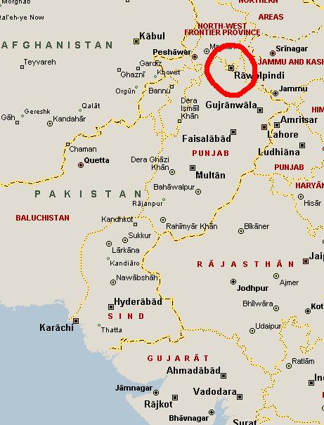
    According to Microsoft Streets & Trips, Pakistan has no Capital.

    Pakistan

    Islamabad should be right there, next to Rawalpindi, but it’s not. You have to zoom way in before it becomes visible.

    In defense of MS Streets & Trips, the symbol allocated to Islamabad indicates that, yes, it is the national capital, however given that Islamabad is a city of only 800,000 while Rawalpindi has 3,000,000, the maps naturally give the larger city precedence when it comes to displaying on smaller and smaller map scales. However, I think that a national capital should override any population schema. Doing some scrolling around the maps at various scales shows that this population bias is common throughout the world and is not Pakistan-centric. It’s a function of population.*

    This shows how GISs can mess with your head when they’re not well thought out. Or how they can mess with your head when your expectations and desires are not the same as the people who designed the GIS in the first place.

    *Although I discovered at Liberia that it’s not just population but a desire of the program to place the name of the country that keeps the capital from being displayed. Monrovia is the largest city in (and capital of) Liberia, but it doesn’t display at small scales because MS Streets & Trips insists on placing the country name approximately centered in the country borders, right where the name for Monrovia would be.

    **Oh, by the way, in an extremely rare event, the map is copyright 2004 Microsoft Inc. No Creative Commons for you, Mr. Map!

  • Geocaching Travel Bug

    Once upon a time, a long long long time ago (2001) I discovered this Geocaching* thing. It sounded cool, so I bought a global positioning system (GPS) receiver and went looking for the nearest cache to me, which at the time was 45 miles away in Plainview, Texas (looking today, I see there are now 194 caches inside that same radius). I alerted some friends of mine about this thing, and a few of them took up the hobby.

    Fast forward 6.5 years. I have a grand total of eight logged caches, all but one gathered in the first year. Mdsteele47** has found 42, Jcronen has 52. Vanepa has found 203. We’re Dead have 638. Aslanspawh has found 1310! He’s a nut.

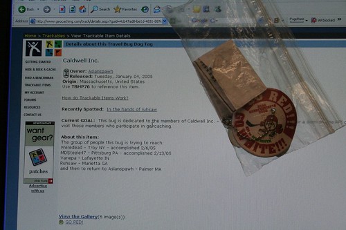
    Anyhow, one of the intricacies of geocaching is a device called Travel Bug. A travel bug is a tag that you can attach to something then place in a cache. The bug has a destination, or series of destinations, and the bug will move from cache to cache (hopefully in the direction it is supposed to go) as people find it and move it along.

    Today, the Caldwell travel bug made its way to hot hands in Marietta. Here’s an image of it.

    Caldwell Travel Bug

    It had intermediary stops in Troy, NY, Pittsburgh, PA, and will continue to Lafayette, IN, and E. Lancing, MI, then finally back to Palmer, MA where it originated. I’ll need to place it in another cache and get it on its way to Indiana sometime soon.

    *At its heart, geocaching is hide and seek with Global Positioning System (GPS) coordinates. One person hides a cache (usually a watertight box of some sort) containing a log book and some goodies, then posts the position of the cache on the geocaching website. The finder then goes out with a GPS receiver and attempts to locate the cache. For more detail go to the geocaching website**.

    **As a part of this blog entry research, I’ve discovered that the geocaching.com website is absolutely terrible. The search engine does not work effectively, i.e. I was unable to pull up the profiles of some of the usernames mentioned above. Their breadcrumbs aren’t operating like breadcrumbs. You can’t look up users. It’s barely possible to navigate, and often you end up back where you were by clicking on different links. It seems to me that all they’ve been doing since 2001 is adding features, not useability.

  • Enhanced Fujita Scale

    Matt Rosenberg alerts us that the Fujita Scale, used to measure the intensity of Tornados (F0 through F6), has been superceded by the Enhanced Fujita Scale.

  • Geology Profound

    Would you like to see what the continents looked like while T.Rex was eating things? How about when the explosion of lifeforms in the cambrian occurred? Maybe what the earth looked like when the dinosaurs were wiped out by the Chicxulub impact at the end of the cretaceous?

    If so, be sure to go to the PALEOMAP Project by Christopher Scotese. Click on the Earth History section to get to the maps. He includes his projections (guesses, really) on what Earth will look like in 100 and 250 million years.

    I didn’t know until looking through this site that there have been times in the past without polar icecaps. I’m not a geologist, and I’ve never really thought about it before. I suppose (now, I’m guessing) that if there are oceans in the vicinity of the poles without landmasses to maintain the ice, it will all float away and melt. Sounds logical, although I have no idea if that hypothesis is anywhere close to accurate.

  • Holy Wrong Hemisphere, Batman!

    German tourist destined for Sydney, Australia ends up in Sidney, Montana, USA! Hey, it’s winter out there, folks!

    Gacked from Matt Rosenberg

  • Gregorian Calendar

    Here are some history and details about the Gregorian Calendar, brought to you by Matt Rosenberg, friendly neighborhood provider of weekly emails concerning geography.

    The most interesting thing (to me) in this article is that it took 170 years to propagate the calendar change throughout all of “western” Europe. That’s a long time for neighboring nations to be on different date-making schedules. Must have made signing treaties that much more tense. (“We’ll use our Calendar.” “No, we’ll use ours!” “Prepare for war…”)

  • Asia -> Spain: Holy Crap that's a long way!

    I’ve been hearing a lot of press recently about the Canary Isands being the port of harbor for African illegal immigration to Europe. The geography makes good sense. The Canaries are only 150 miles (give or take) off of Morocco. Not entirely dissimilar to the Cuban and Haitian boat refugees trying for Florida.

    However, this load of people came a lot farther. All the way from (they suspect) Pakistan and Sri Lanka!

    Wow. I quail under the thought of what those people went through during their trip.

  • Flag Displays in the Classroom

    Over at About.com, the geography man Matt Rosenberg has caused a bit of a rucus in the comments of this post.

    Do you think the Mexican flag should be displayed with “equal promininence” to the US flag in an American Classroom?

    Go! comment on Matt’s entry.

  • Interactive Urbanization History

    The BBC has published an interactive online map to demonstrate urbanization trends of the past 50 years. Rolling their cursor back and forth to watch the asian urbanized centers pop up and grow, then shrink back to nothing, is curiously fascinating. The feature shows N.America as (2005 numbers) 80% Urban population. That makes me wonder what qualifies as “urban.” A quick look around the website and some BBC stories did not net me that information.

    As any good engineer knows, the true understanding of a topic comes at that topic’s edges, i.e., at the boundary of what is considered Urban or Rural (is there a suburban category? I do not know). This philosophy applies everywhere in my life, and it probably applies to people other than engineers, but I can not attest to that very thoroughly. An example of this is the problems regarding gravity and quantum physics. Or, from my field, at the boundaries between where a roadway is operating at an acceptable level, and where it is not (a surprisingly narrow window of travel demand). But I digress…

    This comes from a weekly email I get from about.com featuring geographist (is that a word?) Matt Rosenberg. His missives contain geography tests that I rarely get entirely correct, and I’m usually guessing on half the answers. For example, I only got a 60% on this one. I need to read National Geographic more thoroughly.

    Of course, my opinion regarding “geographic knowledge” is already a matter of public record.

  • Geographically Self-Centered America

    National Geographic released a survey of 18-24 year-old Americans, testing their geographic knowledge. The results, as usual, depress me. The summary of results from the website says:

    • Only 37% of young Americans can find Iraq on a map—though U.S. troops have been there since 2003.
    • 6 in 10 young Americans don’t speak a foreign language fluently.
    • 20% of young Americans think Sudan is in Asia. (It’s the largest country in Africa.)
    • 48% of young Americans believe the majority population in India is Muslim. (It’s Hindu—by a landslide.)
    • Half of young Americans can’t find New York on a map

    The website allows you to take the survey questions (or at least a sample of them; it’s not clear) to see how you do compared to a bunch of people aged 18-24 years. I started answering the questions and had a “huh?” moment. To explain, first let me quote from the official report.

    This survey was designed to test the geographic skills and knowledge of young adults. Three kinds of questions are used to gauge geographic know-how. First, there is a series of questions on factual knowledge of important events and issues in the news.

    I question (from my admittedly non-geography expertise) whether or not “current events” qualify as geography. Here are some samples of the questions that I do not think fit into a geographic-knowledge survey.

      “Which of these cities is the setting for the original television series CSI: Crime Scene Investigation?” (Las Vegas. I thought it was San Francisco, but I’ve never watched the show.)
      “In 2004, what percentage of population growth in the U.S. was due to immigration?” (33%, I thought 20%.)
      “In which of these countries did a catastrophic earthquake occur in October 2005, killing over 70,000 people?” (Pakistan)

    Do these really qualify as geography? Especially the CSI question. Bleah.

    How about this one:

    Which of the following was not a significant contributing factor in Hurricane Katrina’s impact on the city of New Orleans?

    CHOOSE YOUR ANSWER

    • Much of the city was located below sea level
    • The Mississippi River was at record high flow levels
    • Flood protection walls failed
    • Protective coastal marshes had disappeared

    Again, current events knowledge is required to know that the Mississippi wasn’t in Flood at the time of the storm. Now, given that most people should be able to eliminate answer one and three immediately, I’m still not convinced that to have “geographic knowledge” you’re required to know about the flood stages of the Mississippi.

    Other examples from the Web survey which illustrate some non-geographic knowledge requirements for correct answers:

      “Which language is spoken by the most people in the world as their primary language?” (Mandarin Chinese)

    74% said English. 18% said Mandarin. Crazy Americo-centric people!

      “The most heavily fortified border in the world exists between which two countries?” (North & South Korea)

    30% said the border between the US and Mexico was the most heavily defended. This one I find less excusable. Have all these people ignored the whole illegal immigrant issue? How is it possible to think that the US/Mexico border is well-fortified? I blame this one more on illogical thinking and American chauvinism than a lack of geographic skill.

      “Which of these countries is the world’s largest exporter of goods and services measured in dollar value?” (US)

    Lots of people put in China, which I guess is forgivable given the harping on the trade deficit. This actually makes me wonder, what other countries do we have a huge trade surplus with to make up for the deficit with China?

      “World health officials are very concerned about a particular strain of avian flu. Which continent did that strain of flu come from originally?” (Asia)
      “Which of the following countries is the world’s largest consumer of oil?” (US)

    I’m bitching about some of the questions quoted herein, but the survey also tested map-reading skills and other important knowledge. I recommend skimming the report. It makes for interesting reading. For example, some people, if told to evacuate to the northwest in an emergency situation, would go the opposite direction. Oops.*

    So, am I being a parochial engineer and defining “geography” too narrowly, or do my concerns have merit? I don’t know.

    *As an aside, people should become more familiar with the differences between Global Navigation (north, south, east, west) tendencies and Landmark Navigation (go to the drugstore and take a left). These tend to break down across gender lines with Feminine users preferring Landmark and Masculine users preferring Global. In this particular case, for full coverage of all preferences, evacuation authorites should say, “Evacute to the Northwest, toward Hapsburghvillekilltown.” For more information, I highly recommend a brilliant and engaging professor at Georgia State University for this topic: Dr. Jennifer L. Bowie.